Visualize
In Engine Viewer, you can import point clouds (LAS, E57), imagery (planar, panoramic, aerial/orthomosaic), and models (SHP, DXF, IFC) into one interactive 3D view. You can set your projection system to your specifications and customize how all of your assets appear in the viewer.
The user interface is available in multiple languages: English, French, Spanish, German, and Japanese.
We have worked with major sensor companies such as Applanix, Faro, Leica, LidarUSA, NCTech, Riegl, and Trimble to provide native support for visualization and processing of their datasets. We can also manually import many other geospatial datasets produced by other sensors.
Visualize
Develop your project by:
- Aligning your point cloud data with your imagery.
- Adding base maps from ArcGIS World, ArcGIS Street, and OpenStreetMaps.
- Adding points of interest (tags) for your stakeholders.
- Cleaning your point cloud by updating classes or deleting points.
- Clipping your project data to include only the important areas.
- Linking your project to external web pages and applications.
- Arranging your project into folders / floors to help with navigation.
Configure your project as you see fit, and when you are satisfied that it is ready to share with your stakeholders, we provide multiple options for sharing it.
Click on a button to see an example of how you can visualize different geospatial datasets using Engine
An imagery example using a GEOTIFF:
An image only project captured using an MX7:
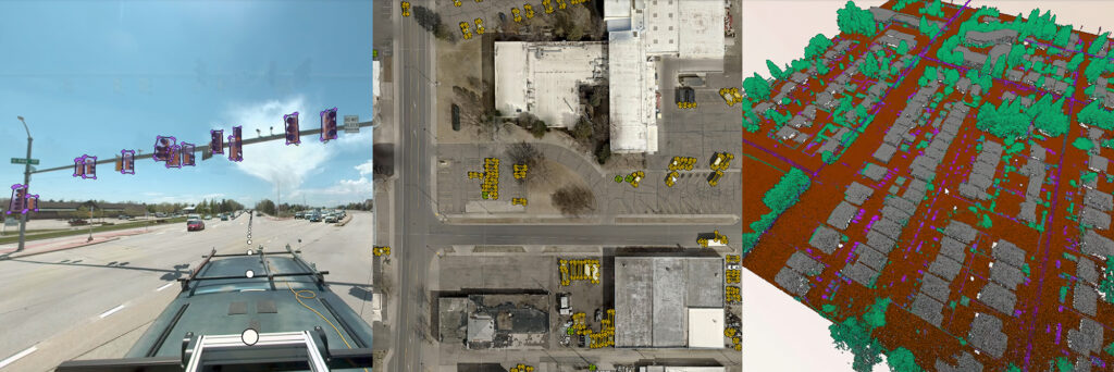
An image project with assets (light poles, which were identified using our deep learning technology) captured using a Mosaic camera system:
An image and point cloud project captured using an MX50
An image, point cloud, and asset (stop signs, which were identified using our deep learning technology) captured using an MX9:
An image, point cloud, asset (information tags), and DXF project, captured using a VMX:
Custom Development and Deep Learning Support
We can adapt Engine to solve a particular problem that you have. Whether you need a specific tool in your workflow, a custom feature or something to meet your stakeholders needs, we are here for you. Our team of geospatial developers and subject matter experts build industry leading technology that meets the needs of many, but we understand that you might have a specific need or requirement to meet your needs. With our in-house deep learning expertise, our team can help you assess your data, develop training data, and then train your model.